port map 1
800 x 1079 px
size 133 Kbytes
port map 2
3388 x 4560 px
size 942 Kbytes
|
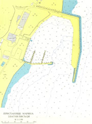
GPS position of main breakwater: N 43° 18.0': E 28° 03.2'
Dangers in approach:Aladja Monastery rocks - east cardinal buoy at N 43° 16.6' : E 28° 04.3'
VHF channels: VHF 16 and 77
Shelter:Good
Charges: $1/m/day, including electricity and water. 36$/m/per year
| Electricity | On quay. |
|---|
| Water | On quay. |
|---|
| Fuel | On quay. |
|---|
| Repairs | There is Yacht Shop possible repairs |
|---|
|

 Login
Login your pictures