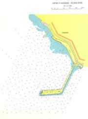
port map 1
800 x 1074 px
size 59 Kbytes
port map 2
1500 x 2014 px
size 209 Kbytes
|
GPS position of main breakwater: N 42° 33. 6': E 27° 38. 3'
Dangers in approach:Pomorie Bank. Only light tower exists. East and south cardinal buoys shown on some charts were not in position. It is not possible to pass between the bank and the mainland.
VHF channels:Port Control VHF 16
Administration: Border police officer will visit the yacht on arival.
Shelter :Good, but open to the the northwest.
| Electricity | Can be arranged. |
|---|
| Water | Can be arranged. |
|---|
| Fuel | Can be arranged. |
|---|
| Repairs | Harbourmaster can arrange. |
|---|
|

 Login
Login your pictures