Login
Name
Password
register
|
lost password
23.04.2024
Home
Coast Guide
Marinas
Refferences
Weather
Charter boats
Galleries
Links
History
Clubs
Sale and Buy
Forum
For us
Áúëãàðñêè
Search
Ïàðòíüîðè
e-locator.net
Yacht harbours and marinas
Harbour Byala
port map 1
800 x 1045 px
size 103 Kbytes
port map 2
1500 x 1960 px
size 234 Kbytes
GPS position of main breakwater:
N42°51.2':E27°53.7'
Dangers in approach:
none
VHF channels:
none
Shelter :
Good
Formalities
none
Charges :
Electricity
none
Water
Tap on quay.
Fuel
none
Repairs
none
NOTE. It is possible some of depths to change over time. Please consult other data sources.
For proposals and questions contact e-mail:
webmaster@bg-sail.org
Copyright information
all rights reserved
PIMDESIGN
2000-2009
your pictures
Black Sea Tall Ships Race 2014 - port Varna - May 01 - 03
[2014-05-08 17:49:30]
News
•
Race 3 victory for Andrew Mills - 2009 FINN SENIOR AND JUNIOR OPEN EUROPEAN CHAMPIONSHIP
•
Perfect Finn racing for opening day - Varna, Bulgaria
•
2009 FINN SENIOR AND JUNIOR OPEN EUROPEAN CHAMPIONSHIP
•
Welcome to the first Kaliakria Cup â Black Sea Regatta in Balchik
•
Medal Round.
all news
Boat charters
Yacht karela
LOA
10.5 m
Crew
1
Cabins
2
Prices
350 BGN
[ all boats ]
Sale and Buy
Sale
786
Buy
52
Find
24
Facebook

 Login
Login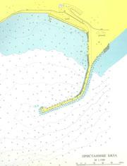
 your pictures
  Boat charters
 Sale and BuyFacebookyour pictures Boat chartersSale and BuyFacebook