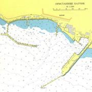
port map 1
800 x 1088 px
size 102 Kbytes
port map 2
3388 x 4606 px
size 904 Kbytes
|
GPS position of main breakwater: N 43° 24.10': E 28° 10.0'
Dangers in approach:From Nos Balchik, east of the harbour, some rocks extend. The light on the end of breakwater is RED contrary to convention.
VHF channels : VHP 16.
Shelter :Excellent.
Charges :leva/m/day.
| Electricity | On quay. |
|---|
| water | On quay , but in short supply. |
|---|
| fuel | Mini tankers call frequently. Y.C. Will advise. |
|---|
| Repairs | Limited mechanical. |
|---|
|

 Login
Login your pictures